

Double-Wheel Geohazard In-Place Inclinometer双轮地灾固定式测斜仪
An automated borehole inclinometer for slopes, landslides, collapse-prone areas and remote geological-hazard sites. The double-wheel measuring string follows deep displacement by depth, supports slip-zone identification and is suited to long unattended monitoring.面向边坡、滑坡、崩塌隐患点和偏远地灾点的自动孔内测斜仪。双轮测量串按深度连续记录深部位移,用于识别变形集中区和潜在滑动面,适合长期无人值守监测。
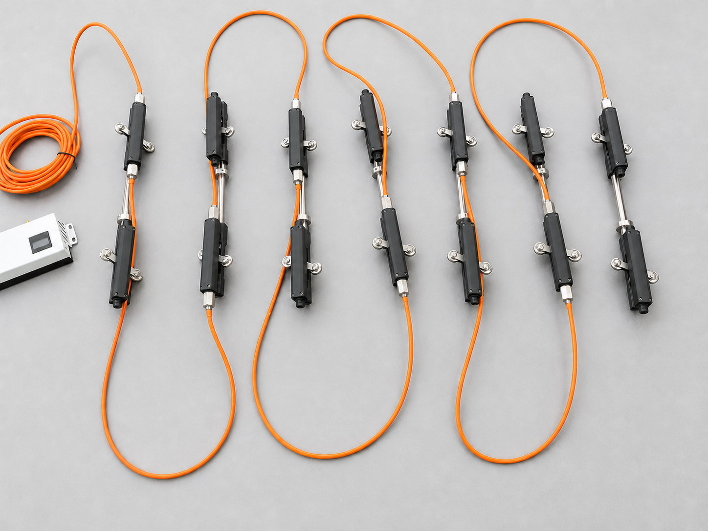
Reliable Deep-Displacement Trends in Remote Terrain在偏远地形持续观察深部位移
- 01Double-wheel guidance双轮导向
Two wheel groups position each measuring section in the casing and help keep the measuring direction consistent through long boreholes.双轮组在测斜管内定位各测量节段,帮助长孔内保持测向一致。
- 020.01 mm/m · 1 m gauge0.01mm/m · 1m 标距
Resolution and ±0.002° repeatability suit long-term trend monitoring of potential slip zones.位移分辨率与 ±0.002° 重复性适合长期观察潜在滑动带趋势。
- 03IP68 / 5 MPaIP68 / 5MPa
Protected for wet boreholes, groundwater fluctuation and long-term outdoor geohazard monitoring.适应潮湿深孔、地下水变化及长期户外地灾监测。
Built Around Geological-Hazard Decisions围绕地灾监测判断来配置
Locate Active Depths识别活动深度
Arrange measuring sections around the expected slip zone and follow displacement by depth through rainfall and groundwater changes.围绕预计滑动带布置测量节段,在降雨和地下水变化过程中观察各深度位移。
Construction and Operation施工与运营期
Use continuous automatic readings at key boreholes while keeping manual or surface control points for comparison.重点孔采用连续自动读数,并保留人工或地表控制点进行对比。
Low-Power Remote Monitoring低功耗远程监测
Pair with solar power, cellular or satellite communication, rain gauges, water-level sensors and GNSS where access is difficult.交通不便时可配太阳能、蜂窝或卫星通信,并联动雨量、水位和 GNSS。
From a Deep-Displacement Profile to the Active Slip Zone从孔内位移剖面判断活动滑动带
The measuring string records deformation at different depths. Comparing cumulative displacement, incremental displacement and rate by depth helps identify where deformation is concentrating and whether the active zone is moving upward or downward.测量串连续记录不同深度的变形。结合各深度的累计位移、增量位移和变化速率,可判断变形集中位置,并观察活动区是否向上或向下发展。
Slopes, Landslides and Collapse-Prone Areas边坡、滑坡与崩塌隐患点
Suitable for deep-deformation observation at natural slopes, engineered slopes, landslide bodies and boreholes behind collapse-prone rock or soil masses.适用于自然边坡、工程边坡、滑坡体,以及崩塌隐患岩土体后缘钻孔的深部变形观测。
Read Displacement by Depth按深度查看位移变化
A sudden change in the depth profile can indicate a concentrated shear or slip zone. Conclusions should be checked against geology, borehole records and the continuing time series.位移剖面在某一深度出现集中变化时,可作为剪切带或滑动面判断依据,并结合地质资料、钻孔记录和连续时序复核。
More Nodes Across the Deformation Zone变形区增加测量节点
After the likely deformation interval is defined, measuring nodes can be placed more closely across that interval, with wider spacing in stable sections to balance profile detail and project cost.明确可能变形区间后,可在该区间加密测量节点,稳定段适当放宽间距,在剖面细节和项目成本之间取得平衡。
Deep Displacement Is Used with Surface and Triggering Data深部位移与地表、诱发因素联合监测
The inclinometer provides the borehole profile. Rainfall, groundwater and GNSS can be added by project so that deep deformation, surface movement and possible triggering conditions are reviewed on the same timeline.双轮地灾固定式测斜仪负责孔内位移剖面。项目可按需接入雨量、地下水和 GNSS,让深部变形、地表位移与可能的诱发因素在同一时间轴上对照。
Double-Wheel Measuring String双轮测斜串
Measuring sections, wheel groups, cables, suspension and borehead accessories are configured for the borehole and target depths.测量节段、轮组、线缆、承重与孔口附件,根据孔况和目标深度配置。
Rainfall, Groundwater and GNSS雨量、地下水与 GNSS
Rain gauges describe rainfall input, water-level sensors follow groundwater response, and GNSS checks movement of the surface block.雨量计记录降雨输入,水位传感器跟踪地下水响应,GNSS 用于核对地表块体位移。
Acquisition and Solar Power采集与太阳能供电
The logger, enclosure, solar panel and battery capacity are selected from sampling frequency, site access and expected periods without sunlight.采集器、机箱、太阳能板和蓄电池容量,按采样频率、现场通达条件和连续阴雨天数确定。
4G, NB-IoT or BeiDou4G、NB-IoT 或北斗
Communication is selected from actual coverage. Public-network sites may use 4G or NB-IoT; BeiDou short message can be considered where no public network is available.通信方式以现场覆盖为准:有公网时可选 4G 或 NB-IoT,无公网区域可考虑北斗短报文,均按项目组合。
A Warning Begins with a Traceable Data Check预警前先完成可追溯的数据复核
Thresholds and response levels are set for each project. A single abnormal point is reviewed together with instrument status, adjacent depths, rainfall, groundwater and surface displacement before a geohazard conclusion is issued.阈值和响应等级按项目确定。单点异常出现后,先核对设备状态、相邻深度、雨量、地下水和地表位移,再形成地灾判断。
Detect发现异常
Rules watch cumulative displacement, incremental change and rate across the depth profile.按孔内各深度的累计位移、增量和变化速率识别异常。
Check Data Health检查数据质量
Review power, communication, missing data and whether adjacent nodes show a physically consistent change.检查供电、通信、缺测情况,并确认相邻节点变化是否符合实际变形规律。
Cross-Validate多源复核
Compare the event with rainfall, groundwater, GNSS and field observations to distinguish deformation from a data anomaly.与雨量、地下水、GNSS 和现场巡查结果对照,区分真实变形与数据异常。
Respond and Record响应并留痕
After review, issue the agreed warning, arrange field verification and retain curves, messages and handling records.复核后按约定等级推送预警、安排现场核查,并保留曲线、消息和处置记录。
Start with the Hazard Model and Borehole先明确隐患类型、变形区和孔内条件
This version is configured by project. No separate SKU is assigned on this page.本版本按项目配置,本页不设置独立 SKU。
| Input选型输入 | What to provide需要提供 | Configuration impact影响配置 |
|---|---|---|
| Hazard and geology隐患与地质条件 | Slope, landslide or collapse-prone area; strata, expected slip surface and deformation zone边坡、滑坡或崩塌隐患点;地层、预计滑面和变形区 | Monitoring depth, reference section and borehole positions监测深度、参考段和孔位 |
| Borehole孔内条件 | Depth, casing diameter and grooves, inclination, water level and installation access孔深、测斜管管径与导槽、倾斜情况、水位和安装通道 | Wheel geometry, string length, cable and installation accessories轮组结构、串长、线缆和安装附件 |
| Installation and acceptance安装与验收 | Casing integrity and orientation, borehead space, suspension point, cable route and initial baseline requirements测斜管完整性与导槽方向、孔口空间、承重点、线缆路径和初始基线要求 | Installation method, borehead arrangement, protection works and baseline-record procedure安装方式、孔口布置、防护工程和基线记录流程 |
| Node layout节点布置 | Target profile detail, expected deformation interval and stable reference interval目标剖面细度、预计变形区间和稳定参考区间 | Closer spacing in deformation zones and wider spacing in stable sections变形区加密、稳定段适当放宽节点间距 |
| Water and environment水压与环境 | Water pressure, temperature, corrosion, lightning and vandalism risk水压、温度、腐蚀、雷击和人为破坏风险 | Instrument protection: IP68 / 5 MPa; cable, cabinet, grounding and surge protection configured separately仪器防护为 IP68 / 5MPa;线缆、机箱、接地和防雷按现场另行配置 |
| Associated observations联动监测 | Need for rainfall, groundwater, GNSS or field-inspection records是否需要雨量、地下水、GNSS 或现场巡查记录 | Sensor combination, common timeline and cross-validation rules传感器组合、统一时间轴和复核规则 |
| Power and communication供电与通信 | Grid availability, solar conditions and coverage for 4G, NB-IoT or BeiDou市电条件、太阳能条件及 4G、NB-IoT 或北斗覆盖 | Power budget, battery reserve, communication link and local storage功耗预算、蓄电池冗余、通信链路和本地存储 |
| Warning workflow预警流程 | Sampling interval, project thresholds, recipients, field-review roles and reporting needs采样周期、项目阈值、接收人、现场复核职责和报表要求 | Cloud rules, notification levels, review records and reports云端规则、通知等级、复核记录和报表 |
Planning a geohazard monitoring project?正在规划地灾监测项目?
Share the hazard type, geological profile, likely deformation depth, borehole plan, water pressure, power and communication conditions.提供隐患类型、地质剖面、预计变形深度、孔位、水压、供电和通信条件,即可开始配置。